Showing posts with label highways. Show all posts

Friday, September 18, 2026

Another Road Trip!

About two weeks ago my mother-in-law wanted to visit her friend from her high school days, who lives in El Cajon, and she doesn't like traveling alone.  Sheila and I were about to do one anyway, but we thought, OK, we'll drive over to the People's Republic, drop her off, and then have four or five days to ourselves.  Two days before our intended departure, she didn't want to be climbing thru those mountain passes so Sheila and I went somewhere else.

As has been the case with our trips, we figure out the night before where we are going to be the first night, and the second night's stop won't be figured out until we're on the way to the first stop.  We ended up in Flagstaff, staying at the Super 8 across from that Himalayan restaurant which is one of our favorite stops.  I thought from there we were going to head west and take historic US66 over to Kingman, but it didn't turn out that way.  The next morning it was decided to go east, which I was good with, since I hadn't been on that stretch of I-40 since 1986, and this time I wanted to get off the interstate where possible and retrace Route 66.

The first stop was in Winslow, made famous by that well-known song that mentions standing on the corner.  We did just that.  We stood at the corner, where some others were also, though in our case there wasn't some chick in a flat bed Ford slowing down to take a look at us.  We had lunch, walked around for two hours or so, and then it was on to our next stop, wherever that would be.

As we were approaching Holbrook, where someone who grew up there once told me, has something of a rivalry with Winslow as far as their high school football teams go, we decided that the next night was going to be in Gallup New Mexico.   I wanted to check out those trading posts in Lupton AZ, on the state line.  Once we saw the price stickers, we got back on and continued.

Gallup has a stretch of US 66 used as a business loop, and with lots of those kinds of stretches you're treated to abandoned buildings that used to be gas stations, and other abandoned buildings that used to be motels.  I'm guessing that half of those motels went under while the other half made it.  We stayed in one of them, and had a memorable meal at Scooter's BBQ.....which we'll do again our next time in Gallup.

Now at this point in the trip, road fatigue was beginning to set in, and we decided that we would spend two nights at our next stop, which was Santa Fe.  I had never been to Santa Fe before but I'd go again, and this time try to have a full weekday there so I can go inside the state capitol.  Downtown Santa Fe was interesting but there was no parking to be had since there was some event that closed off some streets and rendered the paid parking lots full.  We drove around a few neighborhoods, and then went back to the hotel for some rest.  Later on that night we ate at Los Potrillos Mexican restaurant, which was Mexico City style.  

Sunday morning it was back on the interstate again, which meant having to pass thru Albuquerque again, but at that time it wasn't the mess that we saw on Friday.  We continued on down I-25, stopping for lunch at Truth or Consequences and for the night at Deming, after passing thru Hatch and taking the shortcut to I-10.

That turned out to be the third time we've overnighted in Deming, and what used to be our favorite Mexican restaurant was closed since it was Sunday.  I had my heart set on an authentic New Mexico style of Mexican cuisine, which we found at Irma's downtown, and Irma's blew that other place right out of the water.  I had the #1 combo plate, Christmas style, which meant half red sauce and half green sauce.  

The next afternoon we were back home in Tucson, one day earlier than we needed to be, but it worked out for the good as that we got home before a very violent thunderstorm hit our side of town.  The next day it was southeast Arizona getting it, making for some adverse driving conditions.

So, I'm back home, and one thing I'm telling myself is that I need to create a photo album page where I can post pictures of our adventures.  I don't know when I can get to that.  We've got some other irons in the fire right now and one reason for our trip was to get away from them for a week.  The monsoons should be done in a week or so, and I might send out my updated resume as that I'm interested in finding out what kind of contract work is available.  I don't feel a strong inclination to come out of retirement, but I think I need to be aware of what is out there.

That's it for now.

Wednesday, November 13, 2019

A Quick Visit to California

Last Thursday Sheila and I got on a plane for San Jose.  We were picked up by an old friend of mine that I hadn't seen for a long time, that being Craig P, who I heard described as (and I will describe him as that too) "an amazing guy".  He is one of the few from the old days that has remained in San Jose.

The purpose of the trip was to take possession of my dad's pickup truck, and to drive it back to Tucson.  We took Craig, Debbie (a friend of my mother's) and my mother out to a favorite Mexican restaurant of mine, after which there was some bank stuff to do and a visit to DMV.  I had wanted to take to the road at 2:00 PM to beat the traffic rush, but we were held up and didn't leave until 4:00ish.  Traffic was the worst I'd ever seen, but we were able to get into Los Banos for the night.

On most of my road trips, I've taken I-5 down, but with this one, and the previous two, I came down state highway 33 in the central valley.  Sometimes you don't want to be on the interstate.  It was Sheila's first time seeing that part of California, which is enjoyable (you're away from the urban centers).  When we got to Mendota, we headed over to state highway 99, and then it was down that road to state highway 223, through Arvin, and on to Mojave for the night.

It would have been nice to have made Victorville, but I wasn't sure I wanted to attempt I-15 traffic on a Friday afternoon, so Mojave it was.  Our motel of choice was across the street from a Subway that is collocated with a Shell station/convenience store, which is nice as that I got to enjoy a beer with my sandwich.

The next day we were on the road again.  We realized that if we had made it to Tucson, we would have been dog tired that night and useless the next day, so night number three was in Quartzsite, AZ.  I've stayed in Quartzsite a few times and the Super 8 had a room.  I really wanted United States soil under me that night which is one reason we didn't stop in Blight......excuse me, Blythe.

We returned home Sunday afternoon at 1:30ish.  I was tired but not too tired to indulge two very special cats who were glad to see their daddy.  They were on the clingy side that day and the next, (which I had off), and now it's back to work,.

The getaway was nice, but it wasn't long enough.  I really wanted to drive down the coast and visit with my dad in his resting place, but I wasn't sure about US101 and the wildfires that some parts of the coast are having.

About work, I'm going to say this.  Things there have gotten better since I last mentioned it.  I'm seeing the team members work with each other instead of against each other.  I think it's a matter of the divergent personalities learning how to grow together.  It appears in a few weeks I will be involved in testing UHF/SATCOM radios, which is good.  I can't call myself a satellite engineer anymore and that may not happen again, but my desire for that experience is more borne out of a desire to learn some new things.

That's going to be it for the time being.  The holidaze are fast sneaking up on us.  Right now it's the calm before the storm.

Sunday, May 31, 2015

The Month That Was

May is winding down to an end here.  It's been one of the better months.  Sheila flew up here on the evening of the 5th, and on the next day we were out on the road first thing in the morning.  We drove up to Reno on US95, retracing some steps that I had done many years ago.  Not much has changed in that stretch between Las Vegas and Walker Lake, which I last saw in '93. 

We stopped off at the "Area 51 Alien Center" in Amargosa Valley, which has an interesting souvenir shop.  I had been up there in early March and I wanted Sheila to see it.  After she bought some goodies for the kids, we continued on, stopping again in Rhyolite.

Rhyolite is the very first ghost town that I have ever visited.  I was disappointed when I saw it the first time long ago, when I saw those ghost statues near the first building you see.  I couldn't remember if the grotesque statue purporting to be a nude blonde was there back then........it is now, and I hope the model was able to sue for damages.  This time around we spent a half hour exploring the ruins and taking lots of pictures, and I enjoyed it much much better.

Our next stop was Goldfield, the county seat of Esmeralda County.  Esmeralda per the latest figures has some 780 or 820 residents, and 268 of them are said to be living in Goldfield.  The diner we stopped at in 1993 was still there and my recollection is that you could have anything you wanted on the menu, as long as it was chili (and not bad chili either).  About half the buildings, maybe more, have long since been abandoned, and a few of them are in the state of restoration.  The County Courthouse was along the main drag and on the other side of the fence I noticed inmates playing basketball, though the chain link fence had slats in them so that you wouldn't have known they were there unless you really looked.

Upon Tonopah, barely inside Nye County, we encountered thunder.  Yep....and some rain, but not a lot of it.  More rain was had when US95 put us back into Esmeralda County and it was in short sessions of sprinkles.  I didn't remember Walker Lake being that huge.  After Walker Lake, it was uncharted road for us all the way up to Fallon, which I had never been to before.  We liked Fallon and we are now considering that as a retirement venue.  An hour or so later, we arrived at the Siena Hotel in Reno, where we stayed for a couple of days.

The Siena wasn't there the last time I had been in Reno, and that was in 1997.  It was modern and the staff professional.  However, in the parking lot there was a panhandler, and some cars were broken into overnight on our last night there.  We weren't hit, but for some reason those in the row closest to the hotel were.  The telltale signs of window glass told me that five or six had been hit.  Also, there isn't much casino floor security in the Siena as that I was accosted by a panhandler in the men's room.  I didn't say a word, and couldn't find a security officer to have the mendicant ejected.

The next day it was off to San Jose to see my parents, Mark and his wife, and Chip and his family.  After a Mother's Day lunch we were on the road and were able to make it back to Vegas late that Sunday evening.  Monday we visited the Luxor since Sheila wanted to see that, and we hung around Downtown after that.  She flew home Tuesday afternoon, and vacation was over the next morning.

For the Memorial Day weekend, I was back in Tucson for a short visit.  There was more time with our grandchild, and time of course with the cats, who realized that Daddy was home and that meant one more person to boss around.  Oh, they were nice about it, wanting all sorts of love and attention, in addition to a fully stocked food dish. 

Anyway, this was a good month, and it is ending on a hot note.  Las Vegas hit triple digits this weekend.  Good thing all those years in Tucson acclimated me to heat. 

One of my projects should be to post photos of Rhyolite and Goldfield.  It might take two or three postings for both.  So, I guess I'd better get busy and get those pictures on my computer, and resized for blogging.

That's all for now.

Don't forget to pet a dog or a cat!

Tuesday, November 4, 2014

Barstow, CA, 11/4/14

Greetings from Barstow, CA!  I started my drive home to Tucson this morning and decided to take I-40 on the way back.  I felt too tired to push on to Needles, so I stopped here while there was still some daylight left.  I exited CA 58 at Main Street, which is the old 66, and I think I will do one more drive down Main Street before the Interstate again as that it's neat seeing these old motels dedicated to the 66 buff.

It is tempting to jump off of I-40 at Ludlow and to repeat that stretch between there and Needles, but that would make for a longer day......and besides, Sheila's not with me to help me enjoy it.  I did feel a sense of joy taking Main Street in instead of I-15.  I think the old 66 is a neat road, whether you're on the main drag of a small town or out in the middle of the desert. 

* * * * * * *

The start date of my new job is 11/17.  I will be in Tucson for just a few days, before leaving for Las Vegas on Sunday.  Sheila is riding up with me and flying back to Tucson on Wednesday night.  The hope is to have a new apartment located and rented, but I anticipate staying in an extended stay inn for two weeks or so while I wait for utilities to be turned on.  I will drive home for Thanksgiving and for Christmas, and with each return to my new digs I'll haul more things up in my truck.

I will not be able to say very much about my new job.  Although I could identify my new employer, what we're working on is of a proprietary nature.  Yes, you could read about it on their website as well as in some trade publications, but you won't read about it here. 

* * * * * * *

I'm watching election returns on Fox News as I type this.  They are projecting that the Republicans will take control of the Senate, with at least 52 seats.  This isn't really a surprise, and it's not a final number until the Louisiana runoff, but no matter how you slice this it's a reflection of voter anger.

Some eck-spurts are saying that it's a referendum on incumbency, but Republican incuments seem to be doing very well as I type this (with the exception of the Kansas Governor).  I think voters are just plain angry at the White House.

Ebola's been deliberately imported into the country, and the President is refusing to follow the lead of several nations overseas who have closed their borders to the Ebola countries.  Putin has invaded the Ukraine.  ISIS terrorists are beheading American and British journalists.  Health care coverage is being dropped for more people and those who still have it are facing stiffer premiums. 

The Great Leader Messiah isn't leading, but is often seen smiling while riding his girlie bike and wearing mom jeans. 

Yes, this is a referendum on Obama.

The big question here is, are the Republicans capable of recognizing it?  Are they going to stop Obama?  Or are they going to roll over for him, like they have done for the last six years?

The Democrats have demonstrated that they shouldn't be allowed to remain in charge and the Republicans have not demonstrated that they should be trusted to take their place. 

In the meantime, look for an Imperial Presidency that hasn't been seen since the days of Nixon.
 
* * * * * * *

I'm now going to call it a night. 

Tuesday, September 30, 2014

End of Month Situation Report, plus Odds and Ends.

If there's one thing that this month has taught me, is that what you think might happen at the beginning of the month may not be the same as what you think might happen when you reach the end of the month.  I'm talking specifically about the machinations that have been going on behind the scenes that I can't talk about.  In and of themselves they do suggest a light at the end of the tunnel, but at this time I don't know where the other end of that tunnel is.

Once this is over, I'll go into more detail as to what took place.  I don't know when I'll be able to do that, so please stay tuned.

* * * * * * *

The monsoon season, I think, is over.  We had an extension of it thanks to the help of a hurricane which spared Tucson from the intense rain and flooding that other areas got.  Phoenix got some flooding at the front end of the month, and I've been told they got some more a week or so ago.

I should be better informed of things like these days as far as local events go, and I try to be, but my main source of information for southern Arizona now wants to start charging for that information.  As that most of their so-called "news" is editorial opinion in the first place, I'm not paying the charge.

* * * * * * *

I think Sheila and I will end up getting married shortly after the first of the next year.  I've been more focused on fighting my forced retirement than on most other things these days.  There isn't going to be a big wedding anyway.  She doesn't want anyone there except us and the pastor.  I'm not sure, but I think state law here might require a pair of witnesses, and there are about ten people I'd like to see show up for this one.  I'd like for Mark to be the best man, as he was for my previous wedding, but if he can't make it then I've got someone else picked out who will gladly do it.
 
* * * * * * *

The honeymoon won't happen right away after the wedding.  I haven't forgotten that we'd like to do US66 for this one.  If it can be arranged, I'd like to pick up the Main Street of America in Santa Fe, and then take as much of we can of it over to Kingman, and then swing up to Las Vegas for the finale.

* * * * * * *

And that is going to be it for this entry.

Don't forget to pet a dog or a cat.

Friday, February 28, 2014

Route 66! Part XVI: The Final Leg

After leaving behind the gas station at the Cadiz Summit, as you're traveling east towards Needles, the historic highway drifts closer and closer to Interstate 40.  You can almost sense that you're in the final leg of this segment as you have left behind what you saw.  Oh, you can still drive many segments all the way east to Chicago, but as you approach Needles you find that I-40 is now on top of what used to be Route 66.  There was also more than one alignment back to Needles.  This segment that I am presenting is the post-1931 alignment.

All photos in this post were taken 11/30/11.


My recollection is that this abandoned gas station is in what is called Danby.  I might be wrong, as that this might have been Essex.


I think this scene is from Essex.  This final stretch, in my opinion, didn't really provide that much in the way of photographical opportunities of relics.


I imagine that there might still be some hermits living in what's left of this place, but they're probably not very receptive to visitors as that I didn't see any open businesses in this part.


An abandoned old house, behind a chain link fence.


This abandoned gas station is behind a chain link fence.  These days you'd best leave Needles on a full tank if you're going west and wasn't smart enough to tank up in Arizona, as there's nothing on I-40 until you get to Ludlow.  Back in the day of US66, you had more options, though I can't state that gas was cheaper in this remote location than it was in Needles.


I'm not sure what this used to be.  I'm more sure of what it is now:  a graffiti magnet.


This was the last photo that I took on the 11/30/11 trip.  I didn't take any on the 7/16/13 trip.

* * * * * * *

As you're heading east from this point, you rejoin I-40 in ten miles or so, unless you turn off at Goffs Road and take what was the pre-1931 alignment of US 66.  National Trails Highway, which is now what 66 is called in this area, unceremoniously rejoins the Interstate, and you're on the way to Needles.  

As you approach Needles, there is an opportunity to turn off an exit that will take you back to "Historic 66".  We took that last July, and found ourselves going through the main drag of Needles; passing by a Best Western that I've stayed before on a few occasions.  I had no idea that the road in front of Best Western used to be 66, so I traveled the Mother Road without knowing it that time.....and, several years before that along I-15 in the Cajon Pass, as that I've read where southbound I-15 overlays what used to be US 66 until you're at the Cleghorn Road exit.

Passing through the main drag of Needles, you will see the historic shields painted on the road, like you would see in Victorville, Barstow, and along various points of what is now called National Trails Highway.  It's still a neat drive, and I regret not taking any photographs.  

When Sheila and I passed through Needles that day, having enjoyed a drive that both of us would do again in a minute, we followed what we could until we rejoined I-40.  It was time to return to Arizona, and we continued on to Lake Havasu City, and from there we were back home the next day.

As for this drive......I'm very glad that I got to share it with her.  

We both hope to see more of this historic road, and I'd like to think that it will happen later this year, from Kingman to Flagstaff.

* * * * * * *

One final note.  I haven't been posting here a whole lot.  Earthlink gave me another 48 hour Internet outage, the third in six months, and I have since switched to CenturyLink.  It took almost a full two weeks before that switch was complete.  I will post about my Earthlink experience in the near future, but in the meantime, my personal website is now gone, and I don't know if I will replace it on my new host.


Friday, January 31, 2014

Route 66! Part XV: Cadiz Summit

Some six miles east of Chambless, Route 66 does a small climb before it descends back to the desert floor.  At the summit was a gas station called Cadiz Summit Service of which there is slightly more online documentation about it than Road Runner's Retreat.  As far as I can tell this place is named Cadiz Summit but there was never any settlement there.

With this posting, I am going to start off with a photograph that was taken in 1948 by Burton Frasher, according to the source I got it from.  This can be found on more than one web page, and the one that I got was from a photo postcard collection that's at the Pomona Public Library.

The view of this is looking northeast.

Some years after Route 66 was decommissioned as a federal highway, this too was abandoned, and online research tells me that it fell victim to a fire.  What's left are the stone foundations and ruins.  The wooden structure is long gone, and has been replaced with a collection of debris that is typical of abandoned roadside stops in the Mojave Desert.

This is Cadiz Summit as it appears today.  Photograph taken 11/30/11.  This is the easternmost part of the ruins.


A closer look at the graffiti, 11/30/11.


Where the gasoline pumps once stood.  11/30/11.


At the western edge of this site are these ruins.  I would not have known that this was also a lodging site had it not been for that old photograph up above.  11/30/11.


The "entrance", if you will.  I did not go inside.  11/30/11.


Another view.  As I was to find out a year and a half later, there would be new graffiti here.  11/30/11.


Here's a view of the area, looking east, with my truck visible in the background.  11/30/11.


This was a particularly beautiful day that November, gifting me with an unforgettable blue desert sky.


This is one of my favorite shots of the historic shield, taken on 11/30/11; looking west.


When I came back here with Sheila on 7/16/13, I noticed the new graffiti, left by six Canadians (presumably from the Montreal area) the previous May.


Yes, Montreal.  If you look closely at the upper left corner, you'll see the logo of their favorite hockey team.

The eastern structure, from a different angle, 7/16/13.


Saving the best for last!  Sheila, standing alongside the Route 66 shield!

This series is just about over......one more post and we're done with this photo essay.  I will try to get that up here in a few days, so that I can tell you what's gone on in life at this end these past few months.

Saturday, December 14, 2013

Route 66! Part XIV: Chambless

Chambless was another one of the stops along Route 66 that travelers back in the day frequented.  I'm going to guess that we came across this one some six miles after Road Runner's Retreat.  Online research suggests that there are still residents of Chambless, but only six of them.  The town, like Amboy and Ludlow, refuses to to die.  Amboy is being restored by a wealthy owner; Ludlow gets some life from having I-40 next to it (and providing an opportunity for gas if you don't have enough to make Barstow and Needles), but Chambless has no such blood to keep it going.  The only visitors are those who journey this historic highway who stop and take pictures, maybe rearrange some rocks, and then move on.

All photos from this post were taken on 11/30/11.


This is a historical marker in Chambless.  If you click on the photo, you'll be able to read what's on the sign.


I'm not sure what this used to be.  All this does now is tell you where you are in case you don't see the historical marker.


This is looking east.  Nearby this spot some folks have stopped to re-arrange rocks to spell their names.


Looking towards the north.  Stop and think for a moment......many people passed by this spot, in the harsh Mojave Desert, escaping the ravages of the Dust Bowl in the 1930s.  They risked their lives in this journey.  How many people died not far from here; due to a breakdown, lack of water, and lack of help?  This road could tell you a lot of interesting stories if it could talk, but you might not want to hear some of them.


My last shot of this desolate place.  I'm now thinking that I could have taken more pictures, but there must not have been much there as that I didn't take any while I was with Sheila on the second trip.

Next up will be a series of photos further down the road.

Sunday, December 8, 2013

Route 66! Part XIII: Road Runner's Retreat

On my first journey down this historic road in late 2011, I knew that I was in for an adventure, but I did not know just what it was that I would see.  I had seen the abandoned gas stations, the decaying structures, the old motel rooms, the Amboy Crater, but there was still more to see.  At this point Amboy had disappeared into the rear view mirror but the desertscape was still surrounding me.  I had seen this desertscape before on I-40 and now I was seeing it again but from a different vantage point.  I had been seeing several miles of the road and its attendant scenery when somewhere up ahead, there loomed this abandoned restaurant that has since, to me, come to embody what Route 66 was all about.

That restaurant is the Road Runner's Retreat.  I have tried some online research into this and even though you'll see some neat photographs of it, very little seems to have been documented as to its history.  When was it built?  When was it abandoned?  What kind of food was served there?  (I'm presuming hamburgers, fries, perhaps Reuben sandwiches.)

This post is solely dedicated to that interesting relic, which although is no longer in commission, it remains a favorite stopping point of the Route 66 buff.


A closeup of the sign as it appeared on 11/30/11.


Another closeup of the sign, taken on 7/16/13.  Notice the nest that's on the left support.


From further away, on 11/30/11.  In addition to being a stop for eats, one could also gas up here.


A view of what used to be the restaurant.  This is behind a fence, for which I am grateful as that it keeps this from being hit with graffiti.  Yes, I would love to have wandered up to it and gone inside, but this relic can only be enjoyed from a distance.  11/30/11.


A view of the gas station, 11/30/11.


This is the sign as you see it from the other side, looking west.  11/30/11.


Another view.  The gas station was in front of me at this point.  11/30/11.


The gas station, as seen on 7/16/13.


Again, the gas station.  There wasn't any lodging that was here.  This was out in the middle of nowhere, about six miles west of Chambless.  If you were on your way to Needles from Ludlow back in the day, this would have been a welcome sight.  I'd like to think that at one time billboards were advertising it so that the eastbound travelers would have known about it upon leaving Chambless.  7/16/13.


The view from the side of the road, looking north on 7/16/13.  Somewhere beyond those mountains, some twenty miles to the north, is I-40.


The gas station again, 11/30/11.

There was still more of US 66 ahead of me, but when I had first encountered this, I felt like I was really living.  I enjoyed seeing downtown Victorville as well as Amboy, but being here in this spot was therapeutic in its own way.  Even though the ravages of time had taken its toll on this, it made for an interesting stop.

Once again, I find myself wishing that I could go back in time and see Route 66 in its prime.

Sunday, November 17, 2013

Route 66! Part XII: Amboy

Eastbound past the Amboy Crater is the small town of Amboy itself.  This location provides several photographic opportunities for the Route 66 buff as well as an opportunity to stop at Roy's, a small cafe that's still operational.  The motel that it's next to, however, is not offering lodging although I'm sure it was active in its prime.

As a reminder, if you wish to view larger photos, just click on one of them and you'll be treated to a gallery.  Unfortunately, the captions will not accompany the slideshow.  I've got a lot of these with this posting.  Enjoy!


Roy's Motel sign as it appeared on that clear blue skies day of 11/30/11.


The gas station is still operational, but in this remote location it's even more expensive than it is in Needles.  7/16/13.


This had to be where you checked in, if you were passing thru in the pre-I-40 days.  The motel grounds are to the right.  This view is looking north.  7/16/13.


The view from across the street, taken on 11/30/11.  The sign is out of the picture and to the right.


A look at the cafe in the westerly direction, 11/30/11.


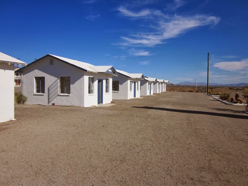
These structures in the front are motel rooms.  Behind these is a chain link fence and a larger structure of more motel rooms, although that back building does not have the rooms detached from each other as they are here.  11/30/11.


On 11/30/11, I was able to go inside one of the front rooms for a look around.  A queen bed would have snugly fit in here.


The entrance to the bathroom.  Through the window, the back building is visible.  11/30/11.


A close-up of the electrical outlet.  This was long before the days of the three prong outlets that are now standard in North America.  I believe these sockets were last used in 1962.  11/30/11.


I took this photo through the chain link fence at the back of the front motel rooms.  The building to the right of this is the now-defunct Amboy School. 11/30/11.


Same building, other end.  11/30/11.


The row of front motel rooms, as seen on 11/30/11.  Did anyone famous stay in one of these a long time ago?


The Amboy Post Office is still in operation.  This is across the street from Roy's.  11/30/11.


Also across the street is this old church.  You can see the steeple leaning off to one side.  This was how it appeared on 11/30/11.


Sometime between November 2011 and 7/16/13, the steeple fell.


This shot, taken 7/16/13, shows the sign, the main lobby, the cafe, the Amboy Crater, as well as my truck (which as I write this, is very close to 400,000 miles!)


I have a weakness for photos with clear blue skies!  This is another one of the main lobby.  11/30/11.


The Amboy School, 11/30/11.


The Main Street of America, looking west.  As Jeff Healey once said in a song from 1990, "Winners and losers all travel the Highway of Dreams".

Our journey will continue in the next post.  My regret about our visit to Amboy is that I missed the "shoe tree" that's to the east.  We'll get that the next time we go down this road.