Sunday, November 17, 2013

Route 66! Part XII: Amboy

Eastbound past the Amboy Crater is the small town of Amboy itself.  This location provides several photographic opportunities for the Route 66 buff as well as an opportunity to stop at Roy's, a small cafe that's still operational.  The motel that it's next to, however, is not offering lodging although I'm sure it was active in its prime.

As a reminder, if you wish to view larger photos, just click on one of them and you'll be treated to a gallery.  Unfortunately, the captions will not accompany the slideshow.  I've got a lot of these with this posting.  Enjoy!


Roy's Motel sign as it appeared on that clear blue skies day of 11/30/11.


The gas station is still operational, but in this remote location it's even more expensive than it is in Needles.  7/16/13.


This had to be where you checked in, if you were passing thru in the pre-I-40 days.  The motel grounds are to the right.  This view is looking north.  7/16/13.


The view from across the street, taken on 11/30/11.  The sign is out of the picture and to the right.


A look at the cafe in the westerly direction, 11/30/11.


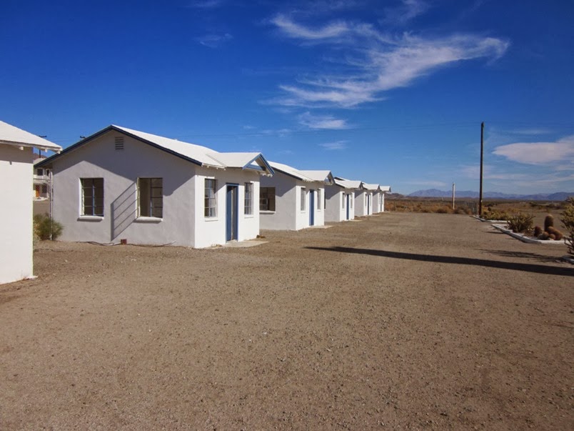
These structures in the front are motel rooms.  Behind these is a chain link fence and a larger structure of more motel rooms, although that back building does not have the rooms detached from each other as they are here.  11/30/11.


On 11/30/11, I was able to go inside one of the front rooms for a look around.  A queen bed would have snugly fit in here.


The entrance to the bathroom.  Through the window, the back building is visible.  11/30/11.


A close-up of the electrical outlet.  This was long before the days of the three prong outlets that are now standard in North America.  I believe these sockets were last used in 1962.  11/30/11.


I took this photo through the chain link fence at the back of the front motel rooms.  The building to the right of this is the now-defunct Amboy School. 11/30/11.


Same building, other end.  11/30/11.


The row of front motel rooms, as seen on 11/30/11.  Did anyone famous stay in one of these a long time ago?


The Amboy Post Office is still in operation.  This is across the street from Roy's.  11/30/11.


Also across the street is this old church.  You can see the steeple leaning off to one side.  This was how it appeared on 11/30/11.


Sometime between November 2011 and 7/16/13, the steeple fell.


This shot, taken 7/16/13, shows the sign, the main lobby, the cafe, the Amboy Crater, as well as my truck (which as I write this, is very close to 400,000 miles!)


I have a weakness for photos with clear blue skies!  This is another one of the main lobby.  11/30/11.


The Amboy School, 11/30/11.


The Main Street of America, looking west.  As Jeff Healey once said in a song from 1990, "Winners and losers all travel the Highway of Dreams".

Our journey will continue in the next post.  My regret about our visit to Amboy is that I missed the "shoe tree" that's to the east.  We'll get that the next time we go down this road.


Sunday, November 10, 2013

Route 66! Part XI: The Amboy Crater

As one is traveling on Route 66 from Ludlow towards Needles, one passes, without realizing it, places where there used to be small outposts.  Bagdad.  Klondike.  Siberia.  I've seen pictures of signs indicating where these once were but I either missed them on both my trips or they're not there anymore.  It is a part of 66 that is desolate, that out-in-the-middle-of-nowhere road in the Mojave desert.  Yet the desert does possess a beauty all of her own; each desert having its own signature characteristic that no other desert has.  The Mojave Desert is no exception to this statement.

Right out in the middle of that desert along the Main Street of America is a geological formation that is a stopping place along that long journey.  It is the Amboy Crater, which is now maintained by the Bureau of Land Management.  I stopped there in 2011 to take these photos which you're now about to see, and I stopped there again with Sheila last July so that she could see it too.


This is a view of Route 66 looking towards the west.  A lava field is visible on the left half of the photo while my favorite highway is on the right.  The road surface you see here is pretty much typical of that stretch between Ludlow and where it joins I-40 some 30 miles or so east of Needles.


In the distance, the Amboy Crater, a long-inactive volcano.  There is now a road to a visitors center which looks like it was constructed recently.  


Lava outcroppings like this are elsewhere in San Bernardino County.  I've seen some along US95, south of Needles.  


A somewhat closer view of the Amboy Crater.  If you're up to it, you can hike to the rim, though this would not be advisable during the summer unless you're in good shape and can carry plenty of water with you.  


And another view, panning to the left.  That particular November day was beautiful.  The temperature was about 75 degrees and the sun was out.  When we were there in July it was hotter but overcast.  


Panning a little further to the left again.  


This view is looking towards the northeast.  In the distance is Amboy.


Back to Amboy Crater, with a view to my right.


This is looking back to the parking lot.  A BNSF locomotive and train are in the distance.


At the unmanned visitor's center is this plaque.  


Here's a shot of the 66 shield in the roadway, at the entrance to the Amboy Crater, taken on 7/16/13.  

A few miles down the road from here is Amboy itself, which will be the subject of the next posting.

Sunday, November 3, 2013

Route 66! Part X: Ludlow

Heading east on Route 66 after Newberry Springs, the historic highway is a frontage road along Interstate 40 once you're past I-40 Exit 23, which is Ft Cady Road.  When I drove 66 in November 2011, I had no idea at that time just how rough of a road it gets.  I wasn't seeing much in the way of ruins; the interstate was to my left, and being slowed down to 25 mph or so (and then driving on the shoulder since it was smoother!) wasn't much to my liking.  When I drove it again with Sheila last July, we got back on I-40 at Ft Cady Road instead of toughing it out to Hector Road, which is Exit 33.  The next I-40 exit after that is Ludlow, Exit 50.

Ludlow is still a busy stop for travelers, but it isn't what it used to be.  People heading in either direction will tank up at the Chevron station in Ludlow as that services aren't available until you're near Barstow heading west, or Needles if heading east.  In front of that Chevron station is Route 66, and I remember taking a long look at it one night back in December 2008, and thinking, so that's it.  That's 66.  I need to drive that some day.

The photos in this posting are of what's left of Ludlow, which declined with the opening of the interstate, but which refuses to fade away.

A historical marker in front of the Ludlow Cafe.  You'll need to click on this to get a better look.  Photo taken 7/16/13.


A display in front of the Ludlow Cafe, which is on the south side of the street.  7/16/13.


Looking west.  You can see my truck at the right edge of the photo.  The old truck underneath the overhang of the abandoned station is not in commission.  When we got closer, we noticed that the tires were flat on it.  7/16/13.


On the north side of Route 66, there is this abandoned service station that did not survive the advent of I-40.  7/16/13.


A closer view of the same service station, taken on 11/30/11.


Another closeup, from 11/30/11.


Looking northwest or so, 11/30/11.


This structure is adjacent to those of the previous photos.  11/30/11.


This wider view, from 11/30/11, shows yet another structure.


On the south side of Route 66 is this derelict.  This was as close as I got.  11/30/11.


Another abandoned structure on the south side of the road that I photographed on 11/30/11.


A different perspective of that same structure from 7/16/13.


From 7/16/13.  That's the same relic three pictures above, but from a distance.


I don't know what this was.  A small mini-mart?  7/16/13.


And finally, the Route 66 shield as painted on the surface in Ludlow.

At this point US 66 bends south from I-40 to follow its own path; not rejoining for several miles or so.  The road surface is much better.  There's also not a lot of traffic on this road save for the other 66 enthusiasts that you'll stumble across.

I didn't know it on the 2011 trip, but the best was yet to come.